Some goals of the St. Louis Geography & History Lesson Plan:
- Map Reading
- Critical Thinking
After reading the provided materials, students should be able to answer the following questions:
- Who was Robert Campbell?
- Where was he born?
- What is a person who comes from another country called?
- Who was Virginia Campbell?
- How many children did the Campbells have?
- How many children lived past the age of 7?
- What businesses did Robert Campbell have?
- Who lived in the house after Robert and Virginia Campbell died?
After reading the provided materials and observing the Campbell House and its surrounding neighborhood, students should be able to answer the following questions:
- Why is St. Louis located at the juncture of the Missouri and Mississippi Rivers?
- Where was St. Louis before 1850?
- What was the Campbell House property before it was part of a neighborhood?
- Why did people live closely packed together in early St. Louis? (1764 to 1850)
- Why did wealthy residents move out of the city?
- What invention allowed people to move further away from their businesses?
- As the wealthy residents continued to move further west after the 1880s, why did the Campbells choose to stay in this house? (open question)
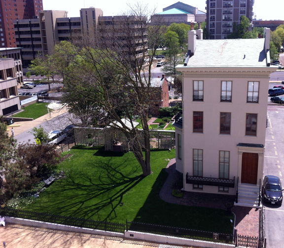
- How many houses can be found on Lucas Place today?
- Where did these homes go?
- What do you see happening around the Campbell House today?
Common Core standards for this lesson: RH.6–8.1, RH.6–8.7, RH.6–8.8, RI.6.3, RI.6.7, speaking elements: SL.6.2 to SL.8.2, SL.6.4 to SL.8.4, collaborations: SL.6.1a‑d to SL.8.1a‑d.
St. Louis Geography & History: Why is St. Louis Here?
St. Louis is a unique place with its own style and history. For more than 10,000 years people have been making a home for themselves here. What is it about this place that had made it a good place to live for so long? (by the end of the lesson students should be able to answer this question.)
The United States and St. Louis
 Look at a map of the United States and find St. Louis. One of the first things you will notice about St. Louis is all of the rivers surrounding the city. St. Louis sits on the western shore of the Mississippi River, just below the mouth of the Missouri River. Just north of St. Louis, on the Mississippi River, is the mouth of the Illinois River and just south of St. Louis is the mouth of the Ohio River. Before railroads and cars were invented, rivers were the fastest and easiest way to travel. St. Louis is the hub of a great waterways system that makes it relatively easy for a person to travel from the Rocky Mountains to the Appalachian Mountains and from the Great Lakes to the Gulf of Mexico, all by water.
The St. Louis we know today is not the first large city in this area. In about 800 C.E. small groups of Native Americans began to come together to create what would become the largest city in North America at Cahokia Mounds, across the river from St. Louis in Illinois. This city lasted until about 1200 C.E. when it was abandoned and its inhabitants spread out to small farming communities throughout the region.
Hutchins’ Map of the Mid-Mississippi River Valley, 1778
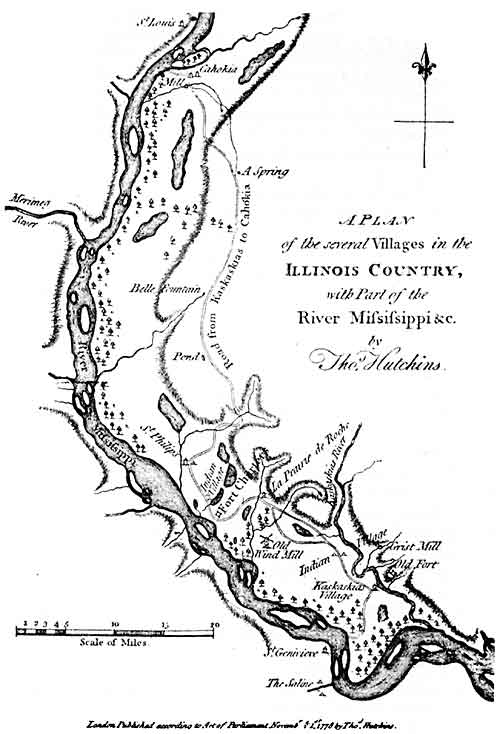 In 1673 France claimed the entire Mississippi River valley as a colony and began to establish missions and trading posts, which quickly evolved into small farming communities along the east bank of the Mississippi River. In 1699, Father St. Cosme established the earliest of these communities in what is now Cahokia, Illinois, in 1699. In 1763 the entire west bank of the Mississippi and New Orleans was transferred to Spain and the east bank became part of the British colonies.
Colonial Map of St. Louis, circa 1800
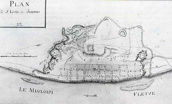 In 1763 a group of traders were given a monopoly to trade with all of the Native Americans west of the Mississippi by the French Governor in New Orleans. One of the traders, Pierre Laclede, led a group of boats loaded with trading goods up the Mississippi in the fall. When he reached Fort de Chartres in Illinois, the commandant told Laclede that he was now in British territory and, to maintain his trading monopoly, he would have to set up his post on the west bank of the Mississippi.
Laclede then went on a trip up the river to find the most suitable spot for his post. He chose the site of modern-day St. Louis because it was the first high ground south of the mouth of the Missouri. This meant that he was close to the people he wanted to trade with and that the site was above the floods on the river. In the early spring of 1764 he sent his 14-year-old protégé, Auguste Chouteau, and a group of boatmen to establish his trading post at what is now St. Louis. With the transfer of the east bank of the Mississippi River to the English, there were many settlers who joined Laclede across the river in St. Louis, which was then Spanish territory.
Within a very short time St. Louis became one of the largest villages in the mid-Mississippi valley. In 1803 Napoleon, the Emperor of France, sold the entire Mississippi River valley and much of what is now the western part of the country to the United States for $15 million; this became known as the Louisiana Purchase. The federal government very quickly began to encourage westward expansion and settlement and St. Louis became the logical place for emigrants heading west to stop and purchase supplies for their trip. By the 1830s, St. Louis had truly become the “Gateway to the West.”
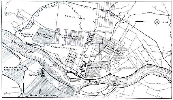
St. Louis Map Showing the Common Fields, circa 1820
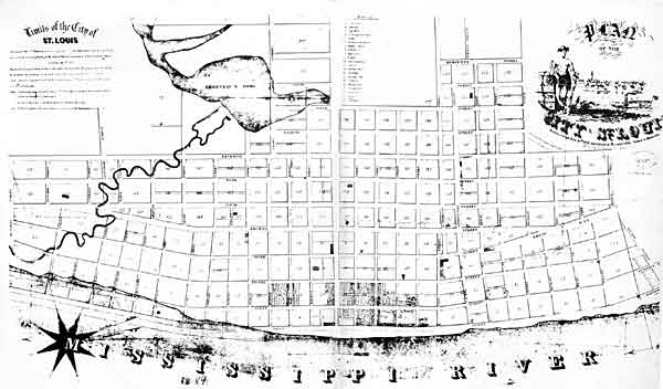
St. Louis Map circa 1845
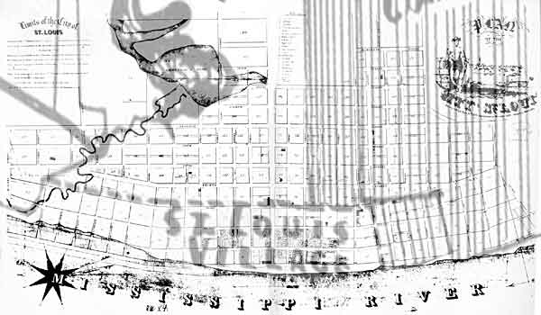
Common Field Map Superimposed Over 1845 St. Louis Map
The City of St. Louis experienced very rapid growth after the Louisiana Purchase in 1803. Around the colonial village of St. Louis were large areas of agricultural land, and when the influx of Americans began after the Louisiana Purchase they began to buy the long narrow lots for their own farms and for development. If you look at the layout of streets in St. Louis, many of them follow the edges of the original 18th century fields. Robert Campbell arrived in St. Louis in 1824 just as this expansion was beginning.
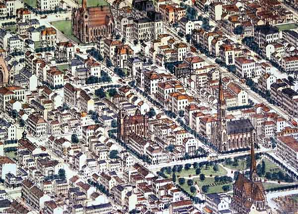
Lucas Place Neighborhood, 1875
In 1850, James and his sister Ann Lucas laid out St. Louis’ first private neighborhood, Lucas Place. It ran along both sides of what is now Locust Street from 13th to 18th streets on three original long lots that James’ father, J.B.C. Lucas, purchased in 1810. When first built the neighborhood was well west of the developed part of the city; in essence the suburbs. Lucas Place, for the first time in St. Louis, allowed the wealthy to separate themselves from the rest of the city. Students can learn more about Lucas Place and St. Louis neighborhoods as a part of our What Makes A Neighborhood program.
St. Louis Street with an Early Horse-Drawn Streetcar
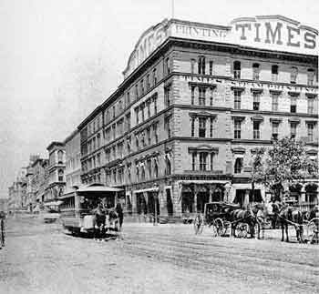 What most allowed people to move further away from their businesses and the river was the introduction of streetcar lines in St. Louis. For the first time, people could move easily and quickly across larger spaces in the city. The first street cars were not electric or steam, they were pulled by mules. In large part due to this innovation, city quickly grew up around Lucas Place, making it less exclusive and removed from the hustle and bustle of downtown. By 1880 Lucas Place residents began to move further west to Vandeventer Place and the Central West End. Today, the only remaining Lucas Place building is the Campbell House Museum.
St. Louis continues to expand quickly. The St. Louis metropolitan area now encompasses 12 counties and extends out from the riverfront forty-five miles in each direction.
